It looked like a shrub on the side of the road – until it moved that is. I pulled up closer and rolled the car’s window down and spring came rushing in. The icy caress of wind chilled by its traverse down snowy mountain sides and the scent of pine told me that winter had been ousted by the prelude to summer. The shrub indeed was a big black bear that too had smelt the passing of winter and had just awoken from its hibernation.
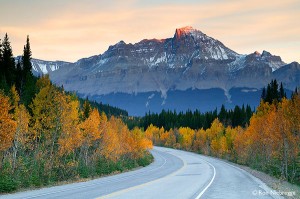
I was in Canada in the state of Alberta, driving down Highway No 93. Better known as the Icefields Parkway, it runs from Lake Louise to Jasper in a 230-km long jaw-dropping scenic overdose. A few years back I’d done a road trip in New Zealand’s South Island and thought there possibly cannot be another place in the world where vista over vista makes you whistle in appreciation. I was wrong! The Icefields Parkway is like that. This road that takes you through the stunning scenery of the Canadian Rockies runs parallel to the Continental Divide which is the chief hydrological divide of the Americas. This is the dividing line between watersheds that drain into the Pacific on tcoast and the river systems that drain into the Atlantic on the east coast. So all along the drive, the geographical drama of the Continental Divide is played out in the form of towering peaks with huge glaciers hanging precariously, deep blue lakes and, of course, the sheets of ice that reach down to the road and form the Columbia Icefield with its 30-odd glaciers. If you look at the map, the classic Canadian Rockies drive runs from Calgary – which is Alberta’s capital -to Jasper in a north-by-northwest direction and goes through the town of Banff. We’d spent the previous day at Banff and were now headed to Jasper when we spotted the bear.
Tourist central
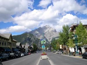 The Cascade Mountain as seen from Banff Avenue
For the tourist who is allergic to tourists, Banff is definitely not on the list. With 4 million visitors a year, Banff is the epicentre of tourism in Canada. This shouldn’t shock too much because while most other mountain towns were discovered by tourism, Banff was created with tourism in mind in the late 1800s with the arrival of the railway and the discovery of the Cave & Basin Hot Water Springs. But, I liked the festive atmosphere that Banff exudes thanks to this influx of people. There is a vibrancy on Banff Avenue, the main thoroughfare that is shared between cars, pedestrians and the iconic shaggy horse-drawn carriages and their fancy dress drivers that give visitors joyrides. People walk the pavements with ice-cream cone in one hand and camera in another while restaurants entice with voluminous menus. The Cave & Basin that was the reason behind the creation of this tourist town is a malodorously atmospheric place to have a look around, nose screwed up against the smell and eyes wide in appreciation. The story is that three railway workers discovered the hot water spring in 1833 and quickly constructed a shack over it and started charging for swims and baths. They became so popular that the government soon stepped in and declared Banff as Canada’s first national park. Today, you can’t swim there anymore but can still tour the cave. Remember that the smell – like that emanating from an egg that has been cracked open after a week in the sun – is from the foul-smelling water that was bottled by The Banff Spring Sanitarium Bottling Company and exported as a remedy for digestive and kidney problems. The trade boomed. The curing capabilities of the water can be attributed to the trace amounts of radioactive materials that are still found in the water to this day.
Postcard vistas
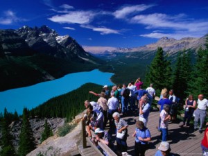
The drive from Banff to Jasper starts getting scenic in earnest after Lake Louise and though the distance from Lake Louise to Jasper can be covered in a few hours, we took an entire day to take in the postcard views and would often stop to explore the uncompromised beauty. Of all the lakes we stopped at en route, the top two were Bow Lake and Peyto Lake, the latter a shade as blue as Frank Sinatra’s eyes.
The science behind the shade is that during summer a large amount of glacial rock flour flows into the lake and these suspended particles give the lake a bright turquoise colour. Then there is the Columbia Icefield which is a remnant of the last ice age and covers 325 sq km. And its star is the Athabasca Glacier that runs so close down to the road that we could park our car and walk to it. We were told by a local that the glacier is so big that the water we were seeing at the toe of the glacier fell as snow about 180 years ago. There are flimsy barricades warning visitors not to cross them and walk on the glacier since the ice looks strong but is even flimsier than the barricades. Falling into the glacier almost always has tragic results and no photo is worth taking the risk. Snaking our way from here towards Jasper we stopped at two waterfalls – the Sunwapta Falls and the Athabasca Falls. Both dropping spectacularly down vertigo-inducing gorges. Since we stopped late in the evening, we had the falls to ourselves after the tour bus traffic had come and gone. Although we were lucky, be prepared to share viewpoints with quite a crowd – up to 2, 00, 000 cars traverse the Icefields Parkway during July and August. I’ll take Jasper over Banff any day. A village that can’t seem to make up its mind whether it wants to grow up to be a town, good-looking Jasper thankfully lacks that tourist sheen Banff wears. It is because travellers come here to shop for adrenaline highs rather than retail rushes. Hands eagerly grab cycle handlebars rather than ice cream cones and explore the wooded trails around town.
A different flight
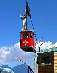
To get our eye-in-the-sky perspective of Jasper we drove to the Jasper Tramway which operates flights to Whistler’s Mountain. The ‘flight’ is actually a cable car ride, but since it whisked us up 3193 feet in seven minutes, ‘flight’ doesn’t seem a terrible exaggeration.
From Whistler’s mountain, Jasper looks J-shaped and handsome. The lakes around Jasper – Patricia, Pyramid, Annette, Edith and Maligne – can be seen as dimples of deep blue on a land speckled with snow-capped peaks and they seem to surround Jasper like maidens vying for its attention. I had two days in Jasper and I wish I had more since there are so many trails to explore, overnight camping trips to indulge in and other outdoor activities that will send an adrenaline junkie tripping. Yet I managed a paddle around Pyramid Lake, a cruise on Maligne Lake to Spirit Island and a 4.9-km hike around Edith Lake. Having burnt a fair cache of calories I could guiltlessly order the huge, sumptuous and juicy rib-eye steak at Nick’s Bar, one of Jasper’s most popular eateries. But, the village’s most boisterous watering hole is the Dead Dog and indeed it is warm, friendly and cavernous. Time just seemed to fly in there and we made our way back to the hotel late that night. The next day we had to put to test the intense coffee that the Bear’s Paw – another popular Jasper institution – freshly brews at 6 am. Truly, it was just what we needed to wash away the dregs of last night’s revelry. It cleared my head for a second dose of the splendid drive that I would do that day – from Jasper to Banff on my way back to Calgary. In the four days I had spent there, spring had taken a firmer grip on the land and wildflowers were defiantly poking through the sludgy snow.
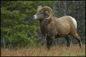
We saw coyotes out hunting, big-horned rams fighting furiously over shy ewes and two more bears foraging through the forest. Snow caps seemed to have receded a bit and trees had lost their snow cover. It seemed a different route altogether; the same road, but a new scenic dose. It would mean a few more gigs of hard disk space eaten up by more photography over the return drive, but I wasn’t complaining.
Rishad Saam Mehta
January 2011
http://rishad.co.in/pdf/Canadian-Rockies-Jetwings-January-2011.pdf
