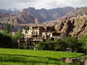
A scenic view of Triund Laka, Dharmashala

As I journey on with the twists and turns of the winding road, my mind keeps going back to Dharamsala, now left behind hidden in forests of pines which stand silent in dark shadows of the approaching darkness. Only a few persistent rays pierce through, rebelling against night setting in. Dharamsala like those rays, is a rebel with a cause. A cause so strong, it pulls thousands of tourists from all over the world. The spiritually starved tourists come to see if freedom has a price… if exile for the Tibetans is as lonely as each one of these tourists feels when among his own people.
Memories flash across my mindscape…

The exodus

I am poring over an issue of Contact, a community magazine run by an American in McLeod Ganj. My introduction to Dharmasala over a tall glass of hot honeyed cider with cinnamon peppering. I realize that at the foundation of Dharamsala, are a people who fled the Chinese occupation of their country, Tibet, led by their religious leader, His Holiness the 14th Dalai Lama. He chose Dharamsala to establish a refugee community in India in 1959. A perfect surrounding for the pursuit of the individual Buddha within. Over the years, the Free Tibet movement developed strong roots and Dharamsala became the Little Lhasa. It is maybe for this very reason that every stranger visiting this recreation of a life and culture, feels an uncanny sense of belonging.

The evidence that Dharamshala was once an abode of the sahibs and memsahibs is reflected in the proud demeanor of St. John in the Wilderness. Derelict and forlorn with its broken stain glass windows, the church stands ever naked to the onslaught of one-day excursions carried out by the umpteen travel agencies in Delhi. While further ahead is Dharamkot, the testament to the Brahmannical era that is almost obscured by time. Dating back to 635 A.D., the Chinese monk-pilgrim, Hsuan Tsang had recorded fifty monasteries with around 2, 000 monks in this fertile region.

Storm in a tea cup

I am walking down the streets, through the alleys and lanes of McLeod Ganj… soaking in every ray of sunlight to warm those cold bones. The inns and handicraft stores with their bright colored warmth dispel the numbness, making the morning forget the gloom and bone chilling discomfort of the night.

A street in McLeodGanj

I enter a restaurant. The usual mélange of nationalities. Israel to Italy to New Zealand. Glasses of tea and joints dangling from their fingers passionately, predictably discussing world politics with a bit of newly gained spiritual understanding and philosophy. Nonchalantly swigging rum while sizing up the Indian walking in.

I walk over to a table thinking of hot noodles with vegetables and some tea. The waiter (also owner) rushes with, “Yaha Khana nahi milta”! My own fumbled Hindi as well as the sudden declaration dazes me. Did I understand wrong or did he mean that his is a restaurant that wouldn’t serve me without even asking me what I want? Stunned, I stumble back in the bright sunlight. Anger seethes and suddenly all of Mcleodganj is a traitor to me in my own land. I simmer thinking how a people who fight for freedom and respect from a tyrant can so disrespect people who have embraced them. “Its my land! How dare they?”, an evil voice swells up within and suddenly all the memories of shop-owners unwilling to show me wares and library which just disposed off books to foreigners refusing to even let me browse through, are awakened.

Average Rating: 4.5 out of 5 based on 220 user reviews.

Late one February afternoon, the M.V. Tipu Sultan steadily put out to sea from the Cochin Harbour. The land gradually receded before our eyes even as the small fishing boats raced back with their day’s catch, the gulls soaring and darting noisily above them, laying claim to their share of the fishermen’s labour. The Chinese fishing nets, those marvels of fishing in coastal waters, hoved along and passed us. An occasional dolphin gambolled out of the sea, shimmering in the sun. The land soon became a distant horizon that would finally disappear behind the curving earth. Then there was only the ship and the sea.

Not quite. The attempt of the blue-back waters of the Arabian Sea to hide it’s denizens was ever so often frustrated as the rebellious flying fish broke out on their short, swift flights. True, they were swallowed again by the sea but they had made their point: We were not the only ones on those waters. Only near the island of Minicoy did something else manifest itself from the deep. A fin was seen coming rapidly towards the ship. Closer scrutiny revealed it to be a hammerhead swimming determinedly right up to the ship. It examined the entire starboard side and then, as if deciding with disdain that it would have no truck with this ship, disappeared into the wake of the Tipu Sultan which went on, to it’s first destination.

The island of Minicoy was sighted after about twenty hours of sailing. When the ship dropped anchor the land was still far off, with the silhouette of it’s lighthouse standing sentinel-like over its mysterious domain, barely visible in the haze. The small, motorised boats with helmsmen expertly manoeuvring among the coral reefs, came up one after the other to the disembarkation doors of the hold. Locals and visitors piled into these ferries and were quickly whisked off to their homes or to strange, enchanting lands.

As the boats pushed on this way and that, safely avoiding the reefs, the island became clearer and clearer. The blue-back waters of the deep sea had melted into sky blue which soon blended into aquamarine and finally the pure green of the lagoon. Beyond, the near-white coral sands beckoned us to cross them and reach the verdant, swaying palms of the coral island. The water was at least twenty feet deep, but so clear that we could actually tell the forms of the corals and anemones swaying as they fed on the sea bed. Scooping out some water in one’s hand revealed it to be as clear and transparent as any self-respecting water should be. Then whence the colour?

To quote Rachel Carson, “The sea is blue because the sunlight is reflected back to our eyes from the water molecules or from very minute particles suspended in the sea. In the journey of the light rays into deep water all the red rays and most of the yellow rays of the spectrum have been absorbed, so when the light returns to our eyes, it is chiefly the cool blue rays that we see.” However, in coral lagoons, the rays of the sun penetrate right to the sea bed, thanks to the clear waters. So the light yellow of the sands is also reflected back and as they mix with the blue, there before you are the turquoise waters!

In less than an hour the boats were tied up along a small jetty and we took our first steps into Minicoy. Even as we marvelled at the crisp white sand under our feet and the green of the palms above, an awesome rattling sound shook us and we looked around, aghast, for its source. It was only the tiller, a sort of miniature tractor, which when attached to cart serves as transport for people and goods of all islands. So we rattled off in these for a “welcome drink”. No, it’s not like those advertised five-star hotels in Goa.

Average Rating: 4.9 out of 5 based on 185 user reviews.

Leh at every step of the breathtaking views-Manali highway, long after the images imprints. In the summer, on the road from the Kullu valley, a stream of buses and Enfield motorcycles in the world, most other road Motorable, 5328m Dizzying Heights with a visit to. The very surface, dirt from the glacial streams on the rough cut is different from the Asphalt. Different river basins with a 485-km ride Sarchu camp at night with a height of 4, 000 m on the highway takes about 24 hours for 3 months on July 15 and 15 (between.) every year. Second season, is closed due to snow.

From Manali, the Rohtang pass road (3900m) for at the beginning of a long climb across the Beas. Sewer as you progress in the reform as long as the eternal snow on the idea, Pastures of grass between the coniferous forests. With just under a breakfast stop for Dhabas to close. There is a temple near the top of a rock, from where you get crown of a great view of the upper Beas valley.

Rohtang La (la means ‘Pass’ in Tibet) Lahul and Spiti means for the difficult areas is the entrance. 5000 passed between the two – meter summit, one in the region to have the most treacherous. Sometimes people suddenly fall season were stuck. Rohtang literally “” means the bodies of the funds.

Gleaming white in the Chandra Pal Valley Massif offers exciting insights to the bottom of the slope to Rohtang. The road is where the river reaches Koksar. Parathas I can not forget, we had it. They were Aaloo parathas, stuffed fried, but served with a saucy Tibetan oil. Finger-licking irresistible!

The next few hours were some of the most beautiful in the whole trip. Since the slopes of the valley with the road works, you can see the high peaks and hanging glaciers. Sacred mountains Rangcha a strong shield around the base of the lunar-Tandi on how to bridge on the river after which Keylong Valley Bhaga Bhaga rivers with your guidance, beyond Keylong, the Bhaga valley broadens. All buses in Darcha stop for lunch here only. A roadside Dhaba with a hot cup of Tibetan Thupka is a favorite. This soup is a dish of Chinese noodles. Tibetan sauce complements the taste of the Thupka. We called Momo Tibetan court was like a delicious samosas.

If you Baralacha La, which are Darcha blow your mind, the road towards the mountain of red wine a row and yellow, green, Boulders How to Zingzing on the bar is rising from the ground than it is uninhabited. The “Twelve” three valleys, Bhaga, the moon and the head of the forms to Yunan horned. By the time you get to Sarchu Serai you’ll be ready for a night’s rest, which is in a tent. It’s a high; straight at the bottom tip of the plane is next to the river Bagha. You dhabas-dal some temporary rice for dinner. To 4:30, you have to watch 5lth further to the visit of several layers of warm clothing protection that do not stop trembling with.

You head to Lachlang La (5, 059m) from Sarchu, the second highest pass on the highway, before descending to Pang at 4, 500m. 3 km from Pang is the extraordinary Moray Plains (4, 800m), a 45-kilometre-long plateau encircled by rolling hills and brilliant white Himalayan peaks.

LA Dibring Tanglang on the road, one of the main camps for the climb to 5328m spinning begins. The best in the world and you have to reach it in time, then his nose started bleeding a little can be done. This is a symptom of altitude sickness. (More on that later), but. From here the Himalayan Karakoram Range, Ladakh video signal that you are. The road to our old Indus (Sindhu) valley is. Indus River, for thousands of years is the lifeline of India. It is a world (Indus Valley civilization) in the oldest civilizations fed. It is, of course, think in terms of the big river.

From Manali entrance to Ladakh is Upshi. This is where the Indian Army, which finished construction and for maintenance of the highway project. Strong in view of the Himalayan region cut off a road maintenance is very difficult. As the freezing point of the project is called, is amazing. Read a road board: “If you want a road to the moon, then contact Himank” please. And we have no exaggeration!

(40 km) from Leh Upshi on the way, there’s high peaks with Gompas homes and villages is crowned. The solid stone structures Gompas Buddhist monasteries, but the big temples.

The first impression was that the industry green with patches of the desert teachers. The first things you notice a Carillons prayers are with the tires. As Leh above sea level is 3, 505 meters, the highest degree a tourist experience altitude sickness. The symptoms constant headache, dizziness, drowsiness, and stuffy nose is bleeding, and include / or lack of breath. It is because your body has not yet acclimatized to the comparative lack of oxygen. So the tourism department suggests you take complete rest for at least 48 hours. Since we can not afford such a rest, we were dealing with the 24 hours before breaking out.

Since we are not already booked accommodation, we went to a hotel / guesthouses. Many of them were filled. Half a kilometer before we run, we were tired. Most of the family who did not have any place so that they were sorry women is managed by the guest house, run! A lovely “Julay” (Ladakhi “Hello”), and also welcomed us with tea.

Ladakhi capital of Leh, sprawls from the foot of a ruined Tibetan-style palace – a maze of mud-brick and concrete. Leh, the capital of the state in the seventeenth century, when his farm here Sengge Namgyal Shey, 15 km southeast of the head of the closer – Khardung China in the Karakoram Corridor. (Khardung to bring the world’s highest, 39 kms from Leh) is.

Ladakh is a travelers and trekkers’ paradise. Backpacks come with their foreign, is growing in different directions. The charm and the former Palace and cities Namgyal Gompa Tsemo included around. A little walk in the fields, Shankar Murals ports and a modern tantric deity Avalokitesvara line thousand small monastery. Just within the reach of picturesque villages and wires in Gompas Shey, a seventeenth century abandoned palace, and Tiks Gompa Hemis Gompa is amazing, this area is the largest site. Of a sitting Buddha Tiks is a large statue.

Leh, the power is very bad. Most of the time, including the night, there was no electricity. By our candlelight dinner is a lot to be forced. Through satellite telephone connections, it is very comfortable with the call by India’s hard to connect. Leh after about 8 months of the world for one year is cut, they (such as construction materials, etc.) for 3 months during the season as the most important things will happen. The only consolation is that almost all the air through the year round has been involved. But the villages on Manali – Leh highway remains completely closed for 8-9 months in a year.

Vijay Satija

Feb 2009

http://www.indiastudychannel.com/resources/49948-Road-Trip-from-Manali-Leh-Ladakh.aspx

Average Rating: 4.9 out of 5 based on 288 user reviews.