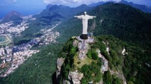
The best way to get to the Christ the Redeemer statue is by cog train through the rain forest.
In Rio de Janeiro you will often hear the Tijuca Forest described as the largest jungle in the world, inside a city. It is not really true – Brazilians love superlatives and it is actually difficult to define what would be an “urban forest” – but the Tijuca National Park is big enough to nest amazing paths and hidden natural jewels. And, best of all, it is only a short bus ride away from Rio de Janeiro’s downtown.
“There are more than 90 kilometres of trails in the Tijuca National Park. It’s amazing to feel you’re deep in the jungle inside a metropolis like Rio de Janeiro, ” said park ranger Thiago Haussig. The 39-square-kilometre park is the first highly successful reforestation project in Brazil, started back in the second half of the 19th Century. Coffee farms had caused widespread deforestation and Rio’s water supply was threatened. In 1861 military police major Manuel Archer was given the order to replant the whole forest with the help of six slaves. And amazingly, they planted 100, 000 trees in less than six years.
It took another 100 years for the forest to be officially designated a national park in 1961 and only over the last decade have tracks been clearly marked and reasonably well kept. The park management claims all of them can be explored without guides but they admit that people do go astray with disturbing frequency. “On average, two groups get lost every year. But we have the resources and the expertise to deal with this and people are always found, ” said Mr. Haussig.
The problem is, there are very few sources of information on the tracks in Rio. The NGO Terra Brasil has a decent website with basic information on the most popular tracks, but the maps are small and lack detail. A few years ago the organization published a bilingual guide (in English and Portuguese), Tracking in the Tijuca National Park, with more detailed information on 90 tracks in the park, but it is out of print. Pedro Menezes de Correa’s Trilhas do Rio is another good out-of-print book on hiking in the Tijuca Forest and beyond. You can look for copies of both in the second-hand bookshops in downtown Rio. The Tijuca National Park management is currently drawing up a new map, expected to be in print around July for the commemoration of the park’s 150th anniversary.
Of the more well known routes, a long and locally popular hike is the one up to the Gavea Stone. The trail begins with two hours of a light track until you reach the Carrasqueira, a steep wall of stone crossed with the use of ropes and helmets. “It’s not really that hard and many people don’t even use the safety gear. But we strongly advise people to take these precautions, ” said Gabriel Werneck, owner of the adventure tour operator Rio Hiking. It takes another hour to overcome the Carrasqueira and then an additional 45 minutes to reach the peak. At 834 metres above the sea, the peak has views of Rio that will take away any breath you may have left after the hike up.
Tracks can also be a fresh approach to visiting traditional landmarks of Rio de Janeiro, like Corcovado Mountain. Instead of riding the touristy tram to the famous mountain-top statue of Christ the Reedemer, you can take a walk to the base through the jungle, past refreshing small waterfalls on the way. The trail begins in the beautiful Parque Laje, neighbouring the Botanical Gardens, and continues through the jungle for two hours. It follows the rails of the Corcovado Tramway for the last half hour of ascent where attentiveness is essential to avoid accidents with the trams. Until a few years ago, travellers walking up the trail would bypass the ticket booths to reach the belvedere on the summit of the Corcovado and the statue of the Christ, but stricter controls are now in place and no one gets there for free anymore.
Paulo Cabral
March 2011
http://www.bbc.com/travel/feature/20110301-trekking-in-rio
Average Rating: 4.4 out of 5 based on 227 user reviews.


